Municipal Assistance Program
Our Projects
Participants
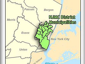
MRRI, Bergen County Municipalities: Carlstadt, E. Rutherford, Lyndhurst, Little Ferry Moonachie, North Arlington, Ridgefield, South Hackensack, Rutherford, Teterboro; and Hudson County Municipalities: Jersey City, North Bergen, Kearny, Secaucus.
The Municipal Assistance Program (MAP) is an initiative developed by the New Jersey Meadowlands Commission Municipalities(NJMC) to assist District Municipalities. A component of this program is to transfer Geographical Information System (GIS) technology and data sets to participating Municipalities. This program is administered through the Meadowlands Environmental Research Institute. District municipalities receive a GIS system that includes current and relevant datasets such as: property boundaries, roads, land use, zoning, census data, municipal infrastructure, and satellite images. In addition, a comprehensive training program for municipal staff followed by technical support and refresher seminars is also part of the program. Services to municipalities under this MAP component include the following:
Database Development and Design
- Municipal database use ESRI’s Spatial Database Engine (ArcSDE) and Oracle 9i to create and manage GIS layers from coverages/ shape files to geodatabase format.
Custom ArcIMS Development
- MRRI-GIS will customize ArcIMS applications to fit the need of the municipality. A user-friendly application is available on the Internet for users to access critical GIS datasets for each municipality. Refer to Interactive Maps.
Interactive Map Training
- Manuals and training are available to municipal staff for use of the GIS.
Data Automation and Integration
- MRRI-GIS is continually updating the State’s parcel data (MOD4) for all municipalities.
Data Automation and Integration
- Capabilities in various modeling and spatial analysis of the Hackensack Meadowlands District and its 14 municipalities. This includes various raster datasets, from Landsat, hyperspectral imagery, to high-resolution ortho-photos.
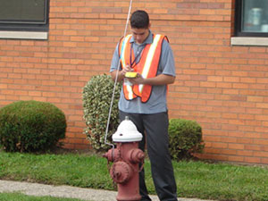
A key component of this program includes the capture of critical data through the use of hand-held GPS units on the field (shown below). For example, fire hydrants of a town can be mapped to show their location and integrity.
Field verification of fire hydrants using GPS unit. Data positions are accurate within sub-meter or better
In addition to the data collection and field work provided, an array of web applications are created for the municipalities to view geo-spatial information on the web. The data can be accessed through the following URL at https://meri.njmeadowlands.gov/gis/maps.html
Number of Towns completed as of September 2006: 13 Towns
Completed
Carlstadt, Secaucus, Moonachie, Teterboro, Ridgefield, Rutherford, Little Ferry, East Rutherford, North Arlington, Lyndhurst, North Bergen, Kearny and South Hackensack


