Flood Warning System
Our Projects
Participants
MRRI, Soon Ae Chun, CSI/CUNY
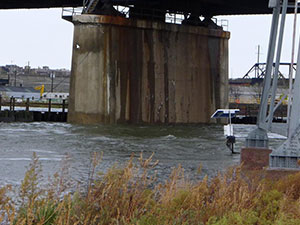
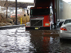
The Meadowlands District (District) experiences frequent tidal and fluvial flooding. 5,100 homes and 2,100 commercial and industrial buildings have been declared within FEMA’s Special Flood Hazard Area. The average elevation of the District is only two feet above normal high tide and more than 3000 acres of landfills are impacted by any significant surge event. MRRI continuously monitors water elevation at critical tide gates in the estuary. There is a need to develop and maintain a reliable District wide water elevation warning system that informs emergency managers and citizens of current water elevations and potential flood areas in and around the lower Hackensack River.
Objective
Our primary objective is to provide emergency managers and the public with real time information on water elevation in the lower Hackensack Estuary. Our secondary goal is to provide a centralized location on the web where emergency managers and the public may post and read emergency field reports from tweets and emails.
Strategy
The warning system is powered independent of the local electrical grid. Measuring stations at the tide gates and in the rivers are solar and battery powered. The electronic equipment that integrates the information from the field and generates the warning exists in a removed geographic location not to be affected by local power outages. The system’s architecture is designed as an integration of modules and automated processes which include:
- Real-time tide gate and river water elevation sensors
- Cell phone and satellite phone data telemetry systems
- Cloud based data integration and warning generation modules
- Manual testing and configuration module
Activities
- Develop the software and hardware connectivity to generate reliable water elevation warnings which are independent from the local electrical grid
- Establish proper water elevation warning criteria
- Develop parcel property flood maps for a range of water elevation scenarios
- Develop a centralized web address for visualizing field reports via tweets and emails
- Compile e-mail and phone lists of emergency managers and officials
- Include module to test and monitor the warning system
Deliverable
- Automated water elevation warning system which is independent of the local electrical grid and that sends warnings via emails and as text messages to cellular phones
- A cloud based web address that centralizes real time twitter feeds from observers in the field